Projekt
Wspólnota
Aktualności
Moja aplikacja
Moje mapy
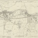
Essex (1st Ed/Rev 1862-96) XX.9 (includes: Brantham; Mistley) - 25 Inch Map
1896
Ordnance Survey
1:3k
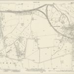
Essex (New Series 1913-) n XXIX.3 (includes: Lawford; Manningtree; Mistley) - 25 Inch Map
1921
Ordnance Survey
1:3k
Essex XX.SW - OS Six-Inch Map
1896
Ordnance Survey
1:11k
Essex XX.SW - OS Six-Inch Map
1896
Ordnance Survey
1:11k
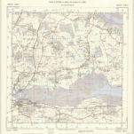
Suffolk LXXXVIII.SW - OS Six-Inch Map
1875
Ordnance Survey
1:11k
Essex nXXIX.NE - OS Six-Inch Map
1921
Ordnance Survey
1:11k
Essex nXXIX.NE - OS Six-Inch Map
1921
Ordnance Survey
1:11k
Essex XX - OS Six-Inch Map
1875
Ordnance Survey
1:11k
TM13 - OS 1:25,000 Provisional Series Map
1938
Ordnance Survey
1:25k
19.The road from London to Harwich in Essex
1780
Ogilby, John (1600-1676)
Historia
Stare mapy Manningtree
Odkryj przeszłość Manningtree na mapach historycznych
Stare mapy Manningtree
Odkryj przeszłość Manningtree na mapach historycznych
Odkryj mapy
Odkryj historię
Region nadrzędny
Essex
Powiązane miejsca