Projekt
Wspólnota
Aktualności
Moja aplikacja
Moje mapy
Mapy Cuckfield
Wyszukiwanie zaawansowane
Wszystkie
Prywatny
Ulubione
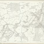
Sussex XXVI.10 (includes: Cuckfield; Haywards Heath) - 25 Inch Map
1874|Ordnance Survey
1:2 500
Sussex XXVI - OS Six-Inch Map
1874|Ordnance Survey
1:10 560
Sussex XXVI.6 (includes: Cuckfield; Cuckfield Rural; Haywards Heath; Lindfield; Lindfield Rural) - 25 Inch Map
1873|Ordnance Survey
1:2 500
Booty's hunting map & environs of Brighton
1863|Booty and Booty
1:123 000
A Pocket Topography and Gazetteer of England. ... Illustrated by maps of the English counties, and vignettes of cathedrals, etc
1842|PIGOT, James AND CO
Reuben Ramble's Travels in the Southern Counties of England
1845|RAMBLE, Reuben pseud. [i.e. Samuel Clark.]
Map of the county of Kent
1860|Edward Stanford
1:286 000
1600
1650
1700
1750
1800
1850
1900
1950
2000
Historia
Stare mapy Cuckfield
Odkryj przeszłość Cuckfield na mapach historycznych
Stare mapy Cuckfield
Odkryj przeszłość Cuckfield na mapach historycznych
Odkryj mapy
Odkryj historię
Region nadrzędny
West Sussex
Powiązane miejsca
© MapTiler
© OpenStreetMap
 1874|Ordnance Survey1:2 500
 1874|Ordnance Survey1:10 560
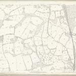 1873|Ordnance Survey1:2 500
 1863|Booty and Booty1:123 000
 1842|PIGOT, James AND CO
 1845|RAMBLE, Reuben pseud. [i.e. Samuel Clark.]
 1860|Edward Stanford1:286 000