Project
Community
News
My App
My maps
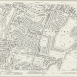
RAF Aerial Collection (1945 - 1949)
1946
RAF
1:5k
RAF Aerial Collection (1945 - 1949)
1947
RAF
1:5k
RAF Aerial Collection (1945 - 1949)
1947
RAF
1:5k
RAF Aerial Collection (1945 - 1949)
1946
RAF
1:5k
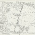
Essex (New Series 1913-) n LXXVIII.2 (includes: Woodford) - 25 Inch Map
1940
Ordnance Survey
1:3k
Essex (New Series 1913-) n LXXVIII.2 (includes: Woodford) - 25 Inch Map
1915
Ordnance Survey
1:3k
RAF Aerial Collection (1945 - 1949)
1947
RAF
1:5k
Essex (1st Ed/Rev 1862-96) LXV.8 (includes: Buckhurst Hill; Chigwell; Ilford; Woodford) - 25 Inch Map
1895
Ordnance Survey
1:3k
A colored plan, on vellum, of ""Luxbrough and Cocksall's Farms, situate in the parish of Chigwell and county of Essex; being the estate of Sir Joseph Eyles, Kent; surveyed and delineated by Thos. Browne, Gent., Blanch Lyon, Pursuivant of Arms, Anno Dom. 1727;"" with a separate plan of ""Browning's and Bird's Farms, situate in the manor of Wolston Hall and parish of Chigwell;"" drawn on a scale of 4 chains (of 72 yards) to an inch: the arms of Eyles impaling those of [Egerton?] are emblazoned at the top.
1727
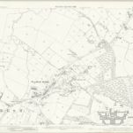
Essex LXV.NE - OS Six-Inch Map
1894
Ordnance Survey
1:11k
History
Old maps of Woodford, London
Discover the past of Woodford, London on historical maps
Old maps of Woodford, London
Discover the past of Woodford, London on historical maps
Explore Maps
Discover History
Parent places
Hertfordshire
Related places