Project
Community
News
My App
My maps
Lancashire CX - OS Six-Inch Map
1845
Ordnance Survey
1:11k
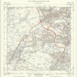
SJ79 - OS 1:25,000 Provisional Series Map
1936
Ordnance Survey
1:25k
Lancashire CX.NE - OS Six-Inch Map
1938
Ordnance Survey
1:11k
Lancashire CX.NE - OS Six-Inch Map
1926
Ordnance Survey
1:11k
Lancashire CX.NE - OS Six-Inch Map
1904
Ordnance Survey
1:11k
Lancashire CX.SE - OS Six-Inch Map
1934
Ordnance Survey
1:11k
Lancashire CX.NW - OS Six-Inch Map
1949
Ordnance Survey
1:11k
Lancashire CX.NW - OS Six-Inch Map
1938
Ordnance Survey
1:11k
Lancashire CX.NW - OS Six-Inch Map
1926
Ordnance Survey
1:11k
Lancashire CX.NW - OS Six-Inch Map
1926
Ordnance Survey
1:11k
History
Old maps of Trafford
Discover the past of Trafford on historical maps
Old maps of Trafford
Discover the past of Trafford on historical maps
Explore Maps
Discover History
Parent places
Greater Manchester
Related places
Places
Carrington, Nottingham