Project
Community
News
My App
My maps
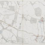
Hampshire & Isle of Wight XLVIII.SW - OS Six-Inch Map
1908
Ordnance Survey
1:11k
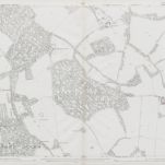
Wiltshire LXXIII.SW - OS Six-Inch Map
1900
Ordnance Survey
1:11k
Hampshire & Isle of Wight XLVIII.SW - OS Six-Inch Map
1895
Ordnance Survey
1:11k
Hampshire and Isle of Wight XLVIII.13 (includes: Melchet Park and Plaitford; Sherfield English; Whiteparish) - 25 Inch Map
1908
Ordnance Survey
1:3k
Wiltshire LXXIII.13 (includes: Melchet Park and Plaitford; Sherfield English; Whiteparish) - 25 Inch Map
1900
Ordnance Survey
1:3k
Wiltshire LXXIII.13 (includes: Melchet Park and Plaitford; Sherfield English; Whiteparish) - 25 Inch Map
1876
Ordnance Survey
1:3k
Hampshire and Isle of Wight XLVIII.14 (includes: Lockerley; Romsey Extra; Sherfield English; Wellow) - 25 Inch Map
1908
Ordnance Survey
1:3k
Hampshire and Isle of Wight XLVIII.14 (includes: Lockerley; Romsey Extra; Sherfield English; Wellow) - 25 Inch Map
1895
Ordnance Survey
1:3k
Wiltshire LXXIII.9 (includes: East Dean; Lockerley; Sherfield English; Whiteparish) - 25 Inch Map
1900
Ordnance Survey
1:3k
Wiltshire LXXIII.9 (includes: East Dean; Lockerley; Sherfield English; Whiteparish) - 25 Inch Map
1876
Ordnance Survey
1:3k
History
Old maps of Sherfield English
Discover the past of Sherfield English on historical maps
Old maps of Sherfield English
Discover the past of Sherfield English on historical maps
Explore Maps
Discover History
Parent places
Test Valley
Related places